Monday, June 19, 2006

English Remidial Task For X SMA DR Soetomo ( Bu Anima )

many people in yogyakarta was deadand many building was broken . all the people in indonesia was scared about tsunami after earta wake many people are sympathy about this accident

Nama :M. Ar raafi r
Kelas:x3
No :28
many people in yogyakarta was deadand many building was broken.all the people in INDONESIA was scared about tsunami after earta wake many people are sympathy about this accident.

Tuesday, June 13, 2006

Remidi B.Inggris"Anis"XI-is~4

Mount Merapi eruption brings back horror
Posted 5/16/2006 2:30 PM ET
E-mail Save Print

var tempshowReprintSSI = "";
if(window.showReprintSSI)
{
tempshowReprintSSI = showReprintSSI;
}
if ((navigator.os.indexOf("Mac")==1) && (navigator.type==2))
{ // macIE
if((document.forms.hiddenValForm.hiddenMacPrintValue.value == "0") (document.forms.hiddenValForm.hiddenMacPrintValue.value=="2"))
{

if(document.forms.hiddenValForm.hiddenMacPrintValue.value == "2"){
document.forms.hiddenValForm.hiddenMacPrintValue.value = "0";
}
else{
document.forms.hiddenValForm.hiddenMacPrintValue.value = "1";
}
if(tempshowReprintSSI == 'showReprintSSI'){
writeReprintLink();
}
writeSubscribeToLink();
}
else
{
document.forms.hiddenValForm.hiddenMacPrintValue.value = "2";
}
}
else
{// non macIE - write top and bottom

if(tempshowReprintSSI == 'showReprintSSI'){
writeReprintLink();
}
writeSubscribeToLink();
}

function writeReprintLink(){
document.write('Reprints & Permissions ');
}
function writeSubscribeToLink(){
var url = document.location.toString();
var urlArray = url.split("/")
var nurl = "";
for (i = 3; i ');
}


Subscribe to stories like this

Enlarge
By Ed Wray, AP
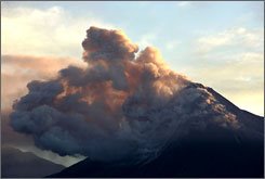
Mount Merapi, in the middle of Indonesia's Java island, continues spewing lava and gas clouds Tuesday.
swapContent('firstHeader','applyHeader');
MOUNT MERAPI, Indonesia (AP) — The sky went black and a thunder-like roar filled the air. Some witnesses remember hearing one or two explosions. But few had time to see the searing hot gas cloud surge from the volcano before it engulfed their village, incinerating 60 people.
That was in 1994. Now, with Indonesia's Mount Merapi again emitting lava and gas clouds, survivors of the last eruption a dozen years ago told of its horrors — and urged people resisting evacuation this time to flee the danger zone.
"The trees caught fire and everything fell down" in 1994, said Maryoto, who sustained massive burns to his face and body. "I was aware of what was happening, but couldn't feel anything. It was so hot." Like many Indonesians, Maryoto uses one name.
The volcano in the middle of Java island continued spewing lava and gas clouds Tuesday, but not as violently or often as a day earlier, which saw the most activity since the peak began erupting again several weeks ago.
The relative lull did not mean the danger was over, scientists cautioned.
"That is Merapi," said Ratdomopurbo, the region's chief vulcanologist. "She is always fluctuating."
Scientists monitoring Merapi say the current activity will not result in a massive horizontal explosion, but warn that villagers living high on its slopes are again at risk of pyroclastic flows.
The flows are made up of a lower layer of coarse rock fragment, that bursts forth like a shotgun blast. The top layer is composed of turbulent ash and volcanic gas. They move together at speeds of 50 to 100 mph, and reach temperatures of up to 1,500 degrees.
Like most victims on the morning of Nov. 22, 1994, Maryoto was at a wedding in Turgo village on the mountain's western slopes when the 9,800-foot peak erupted.
He was in the kitchen and was trapped under one of its walls, perhaps shielding him from the heat and saving his life.
Maryoto, 50, lost nine family members, including his younger brother.
The intense heat melted both his ears, and many of his fingers and toes.
His wife, Kasiyem, was selling vegetables in the market when the volcano erupted. She was unharmed. When it was finally safe to return home, she said, she saw bodies that were "black, scorched — just like pieces of coal."
The pair now live with 120 other survivor families in a cul-de-sac the government built especially for them. It lies 2 1/2 miles below their old village, far enough from the peak to be considered safe.
Turgo has since been repopulated, but has been off-limits since Saturday, when the government ordered the evacuation of its inhabitants, along with about 5,000 other people closest to the crater.
Officials are manning barricades on the roads leading to the evacuation zone, stopping vehicles from entering. However, they let residents return to their fields and livestock during the day.
A few young men are allowed to stay in the villages overnight to guard against thieves.
But some people are refusing to leave at all, citing mystical beliefs that spirits watch over the volcano and will warn them if there is any danger.
"You can buy possessions, but you can't replace lives," said Kasiyem in an interview on the porch of the couple's two-room house. "They should come down."
Other survivors of the 1994 eruption said the mountain showed no sign of increased activity beforehand and that they received no warnings from the government's volcanology center.
The sight of more clouds on the mountain — locally called "shaggy sheep clouds" because they resemble tightly curled balls of wool as they roll down the slopes — has stirred bad memories for many.
"My friends said come and look at them (the clouds)," said Poniyem, who lost her 3 1/2-year-old son and her mother and father in the disaster, and was badly burned on her legs, hands and back. "I said to them, 'No way,' and stayed in the house."
Copyright 2006 The Associated Press. All rights reserved. This material may not be published, broadcast, rewritten or redistributed.
Remidi B.Inggris"Debby"XI/Is~3 No.10

Kangaroo Island
Kangaroo Island is fresh air, pristine beaches and dramatic scenery. It’s also one of the best places in Australia to see wildlife in the wild. Cycling, diving, farming, walking, four-wheel drive tours and fishing all adhere to the rules of eco-friendly treatment. Walk close to wildlife.
Advertisement

Advertisement


Advertisement

Advertisement


Wildlife wonderland
With very few introduced species about, the native wildlife thrives. Look up and see koalas and flocks of birds. Look down and see kangaroos, wallabies, goannas, echidnas, possums and platypus. Along the coast dolphin and seals frolic, little penguins come to roost at night and you can walk among sea lions. more info »

Parks and refuges
Having separated from the mainland during the last ice age Kangaroo Island has many plants and animals no longer found elsewhere. Thirty per cent of the island is protected to preserve this heritage. Interpretive tours visit parks and protected waterways or do it yourself with the Walking Trails brochure. go to...

Unique accommodation
Meet the locals in a charming bed and breakfast, hostel or farmstay. Look after yourself in a beach house, cottage, caravan park or camping grounds. Be pampered in a hotel, motel or a stunning hideaway. more info »

Flinders Chase National Park
Flinders Chase National Park, a wilderness and wildlife haven on the south-western tip of the island, is known for its woodland and stunning coastline. It takes in the 74,000 hectare Ravine des Casoars Wildlife Protection Area.

Remarkable Rocks
Worn by centuries of wind and rain the Remarkable Rocks rise above the sea like a sculpture park. Gigantic rocks have been honeycombed, hewn and hollowed into dramatic shapes.

Walk with sea lions
At Seal Bay enjoy the unique experience of walking among huge sea lions sleeping, playing and nursing their young. Then visit Admirals Arch where fur seals romp in the crashing waves. more info »

All natural food
Island farmers are proud of their clean-green tradition of free roaming livestock and nature-ripened produce. Enjoy a diverse menu of naturally fresh seafood, honey, cheeses with home-grown wine more info »

Tugas B.inggris"Fenny"XI-IS~3 No.19

Great Ocean Road
Winding around dramatic cliffs with the surf of the Southern Ocean swelling below, Victoria’s Great Ocean Road passes beaches and coves, quiet seaside villages and spots to enjoy brilliant sun and surf.


Beach heaven
Some of the world's best beaches are found along the Great Ocean Road. From protected family coves to pounding surf there is a stretch of coast to suit. Some beaches are patrolled by lifeguards in summer. more info »

Great beach walks
One of the most popular walks is the Gibson Beach Walk near Port Campbell. Starting down steps cut into sheer limestone cliffs 100 years ago, you arrive on a stretch of beach near two of the Twelve Apostles. more info »

Surf's up
Recognised as one of the best stretches of surfing coastline, visitors are strapping their boards to their cars and heading on down. One of the most popular beaches for experienced surfers is Bells Beach.

Beneath the waves
The Great Ocean Road’s rocky headlands, offshore reefs and historic shipwrecks provide varied scuba-diving and snorkelling experiences. Key spots are from Port Campbell and Peterborough where gear can be hired.

Whales and wildlife
In winter, the Great Ocean Road becomes a viewing spot for southern right whales. One of the best vantage points is on Logan’s Beach, Warrnambool Foreshore, where you may also see bottlenose dolphins. Australian fur seals are best seen from Cape Bridgewater. On the land, there are koalas and kangaroos, and for birdwatchers, Griffiths Island at Port Fairy has a large colony of short-tailed shearwaters. go to...

Tugas B.INGGRIS"DHANI"XI/Is~3 no.9

great barrier reef
This natural wonder is as big as Britain and Ireland combined, has more than 1,000 islands, from sandy cays to rainforest isles, and supports prolific marine life. You can reach coral sites by air and water taxi, and scuba dive or snorkel. Click on the fact sheet below to discover comfortable accommodation available on secluded islands.


World Heritage marvel
The majestic coral structures that make up the World Heritage-listed Great Barrier Reef extend over 2,500 kilometres from Cape York in the north and Bundaberg in the south. It has the most diverse animal and plant ecosystems on earth.

Tropical reef delights
As the reef meets the coast in Tropical North Queensland, access to explore the coral delights becomes easier. Between Townsville and Cairns, there are ideal setting-off points and many expeditions offered by dive companies and cruise operators.

Whitsunday coral gardens
Coral gardens lace nearly every Whitsunday island, offering sheltered spots for snorkelling, diving and relaxing line-of-sight sailing in the tropical waters. Visitors thrill to see the coral formation of Heart Shaped Reef at beautiful Hardys Reef.

Easy access to islands
Great Keppel and South Keppel islands offer resort or rustic getaways a boat ride from Yepoon. Heron Island, near Gladstone, is a seabird and turtle haven. The reef's two 'ladies' - Lady Elliott and Lady Musgrave - are handy for day trips or longer stays. more info »

Idyllic island escapes
In the reef's tropical northern waters, lush Green and Fitzroy islands are a day's excursion from Cairns. Popular Dunk Island is only minutes from Mission Beach, just north of Cairns, and Bedarra, Hinchinbrook and Orpheus islands lie dreamily nearby.

Tugas Remidi B.inggris"Tomi.R"XI/IS~3 NO.47

Uluru
Uluru (Ayers Rock), in the centre of Australia, is the world's biggest monolith at 3.6 kilometres long, two kilometres wide, 348 metres high and 9.4 kilometres round. Uluru, which belongs to the Anangu Aboriginal people, changes colour in different lights, particularly at sunrise and sunset.
Advertisement


Advertisement


Creation significance
Uluru holds a significant place in the Anangu people's creation stories and laws, known as Tjukurpa. Many stories relate to how ancestral beings formed the rock. Aboriginal guides share these ancient tales with visitors on tours around Uluru's base. more info »

Dramatic formation
Uluru is composed of steeply dipping, feldspar-rich sandstone arkose, which has been exposed through folding, faulting, the erosion of rock and infill. At the base, there are caves, inlets and overhangs formed by chemical degradation and erosion.

Scenic rides
Aside from a walking tour, one of the best ways to enjoy Uluru is a motorcycle tour. About a dozen companies offer scenic rides or rent out bikes. Sunrise and sunset are prime times to be out touring, as the rock changes colour with the light.

Desert explorers
Visitors can experience the outback from the backs of camels, once the main way of getting around in the outback. Camel tours at Uluru capture the essence of camel-back exploration with a choice of escorted rides across the desert sands.

Bird's eye view
An unforgettable way to experience Uluru is a flight in a light aircraft or helicopter for a bird's eye view of the monolith and surrounding plains. The experience varies with the season or time of day, but the memories can last a lifetime.

Uluru's true meaning
Walks around Uluru with Aboriginal guides offer a spiritual interpretation and an understanding of its history. Visitors can retrace the path the Liru ancestors made to Uluru and see scars left on the rock from battling Kuniya thousands of years ago. more info »

Taking to the road
A trip for the adventurous and well-prepared takes in Central Australia's most spectacular sights on the Mereenie Loop, a quality unsealed road linking Uluru with Alice Springs, via Kings Canyon, the West MacDonnell National Park and Glen Helen Gorge. more info »

Tugas Remidi"B.inggris"M.Huda"XI/IS~3 No.24

"Sydney
Sunny, sexy, sophisticated - Sydney basks as the shining star of the southern hemisphere. The stunning Sydney Opera House and Sydney Harbour Bridge are the pride and joy, but there's much more on offer.


Fabulous fusion foods
Decades of immigration have meant Sydney's restaurants cater for all sorts of tastes from Greek and Lebanese to Japanese and Indian. Fresh ingredients and a fusion of Eastern and Western styles are an Australian trademark, while superb wines and scores of bars and pubs will quench your thirst. more info »

Australian Style
Light, bright, cheerful and colourful - Sydney style has an exuberant quality defined by the city's climate, magnificent harbour, luxuriant hinterland and superb beaches. Voluptuous rather than sharp-edged, gorgeous rather than chic, the New South Wales capital dazzles with personality. more info »

A jewel of a harbour
Sydney's sparkling harbour is the jewel in the city's crown. It's flanked by golden beaches and bushland, and is bisected by one of the most famous bridges in the world. Islands sprinkle its waters, and it's crisscrossed by all manner of craft, from water taxis and yachts to tour boats and ferries. more info »

Around the clock
They say that Sydney never sleeps. In daylight hours the city buzzes with life and performances while all-night pubs, cutting-edge dance clubs, and gay reviews on trendy Oxford Street, can keep you out until dawn. Fancy a late-night meal or a final coffee - that's not a problem in Sydney. more info »

adUrls[2] = "http://ad.doubleclick.net/adj/ta.eu/places_to_go;sec=places_to_go;sec=places_to_gocitiescities_sydney;l=en;c=GB;tile=2;sz=165x90;ord=530341;";

adUrls[3] = "http://ad.doubleclick.net/adj/ta.eu/places_to_go;sec=places_to_go;sec=places_to_gocitiescities_sydney;l=en;c=GB;tile=3;sz=165x90;ord=530341;";

adUrls[4] = "http://ad.doubleclick.net/adj/ta.eu/places_to_go;sec=places_to_go;sec=places_to_gocitiescities_sydney;l=en;c=GB;tile=4;sz=165x90;ord=530341;";

adUrls[5] = "http://ad.doubleclick.net/adj/ta.eu/places_to_go;sec=places_to_go;sec=places_to_gocitiescities_sydney;l=en;c=GB;tile=5;sz=165x90;ord=530341;";

adUrls[6] = "http://ad.doubleclick.net/adj/ta.eu/places_to_go;sec=places_to_go;sec=places_to_gocitiescities_sydney;l=en;c=GB;tile=6;sz=165x90;ord=530341;";

Monday, June 12, 2006

Remidi Bhs.Ingg"Anindita" XI/IS~3

Nama: Anindita.A.R
Kelas:XI/IS~3
No:02

great barrier reef

This natural wonder is as big as Britain and Ireland combined, has more than 1,000 islands, from sandy cays to rainforest isles, and supports prolific marine life. You can reach coral sites by air and water taxi, and scuba dive or snorkel. Click on the fact sheet below to discover comfortable accommodation available on secluded islands.

World Heritage marvel
The majestic coral structures that make up the World Heritage-listed Great Barrier Reef extend over 2,500 kilometres from Cape York in the north and Bundaberg in the south. It has the most diverse animal and plant ecosystems on earth.


Tropical reef delights
As the reef meets the coast in Tropical North Queensland, access to explore the coral delights becomes easier. Between Townsville and Cairns, there are ideal setting-off points and many expeditions offered by dive companies and cruise operators.


Whitsunday coral gardens
Coral gardens lace nearly every Whitsunday island, offering sheltered spots for snorkelling, diving and relaxing line-of-sight sailing in the tropical waters. Visitors thrill to see the coral formation of Heart Shaped Reef at beautiful Hardys Reef.


Easy access to islands
Great Keppel and South Keppel islands offer resort or rustic getaways a boat ride from Yepoon. Heron Island, near Gladstone, is a seabird and turtle haven. The reef's two 'ladies' - Lady Elliott and Lady Musgrave - are handy for day trips or longer stays. more info »


Idyllic island escapes
In the reef's tropical northern waters, lush Green and Fitzroy islands are a day's excursion from Cairns. Popular Dunk Island is only minutes from Mission Beach, just north of Cairns, and Bedarra, Hinchinbrook and Orpheus islands lie dreamily nearby.

tugas remidi"Anang.s"XI/Is~3 B.INGGRIS

Nama:Anang.S
Kelas:XI/IS~3
No:01

Uluru

Uluru (Ayers Rock), in the centre of Australia, is the world's biggest monolith at 3.6 kilometres long, two kilometres wide, 348 metres high and 9.4 kilometres round. Uluru, which belongs to the Anangu Aboriginal people, changes colour in different lights, particularly at sunrise and sunset.


Advertisement


Advertisement


Advertisement


Creation significance
Uluru holds a significant place in the Anangu people's creation stories and laws, known as Tjukurpa. Many stories relate to how ancestral beings formed the rock. Aboriginal guides share these ancient tales with visitors on tours around Uluru's base. more info »


Dramatic formation
Uluru is composed of steeply dipping, feldspar-rich sandstone arkose, which has been exposed through folding, faulting, the erosion of rock and infill. At the base, there are caves, inlets and overhangs formed by chemical degradation and erosion.


Scenic rides
Aside from a walking tour, one of the best ways to enjoy Uluru is a motorcycle tour. About a dozen companies offer scenic rides or rent out bikes. Sunrise and sunset are prime times to be out touring, as the rock changes colour with the light.


Desert explorers
Visitors can experience the outback from the backs of camels, once the main way of getting around in the outback. Camel tours at Uluru capture the essence of camel-back exploration with a choice of escorted rides across the desert sands.


Bird's eye view
An unforgettable way to experience Uluru is a flight in a light aircraft or helicopter for a bird's eye view of the monolith and surrounding plains. The experience varies with the season or time of day, but the memories can last a lifetime.


Uluru's true meaning
Walks around Uluru with Aboriginal guides offer a spiritual interpretation and an understanding of its history. Visitors can retrace the path the Liru ancestors made to Uluru and see scars left on the rock from battling Kuniya thousands of years ago. more info »


Taking to the road
A trip for the adventurous and well-prepared takes in Central Australia's most spectacular sights on the Mereenie Loop, a quality unsealed road linking Uluru with Alice Springs, via Kings Canyon, the West MacDonnell National Park and Glen Helen Gorge. more info »

English Remidial Task for X SMA DR Soetomo (Bu Anima)

Tugas remidi Bahasa Inggris bagi siswa kelas X adalah membuat laporan ringkas tentang gempa di Jogyakarta. . Untuk materi dapat diperoleh dari situs :


pilih salah satu artikel di situs tersebut kemudian buat ringkasannya dan postkan ke ruang diskusi Bahasa Inggris. Semuanya kerjakan berdasarkan lembar panduan yang diberikan.

Remidi bhs inggris Andre XI Is 2

Pattaya A Travelers ParadisePattaya is nestled along a picturesque bay on the East Coast of the Gulf of Thailand, roughly 170 kilometers southeast of Bangkok. From a fishing village in the 1960's, Pattaya has emerged as the favorite Southeast Asian vacation center. A fascinating escape where tourists, holiday makers and vacationers from around the world unfold an incomparable array of possibilities to unwind during an exotic holiday beach vacation.

Kelas Xi Is 2
Andre Eko Putra
No abs 07

Sunday, June 11, 2006

:: General Information
A province in the Lower North, Uttradit has a long history developing through the years since pre-historic time.

The site of the original town, then called Bang Pho Tha It, was located on the right bank of the Nan River. It flourished as a port for goods transportation. As a result, King Rama V elevated its status into a province and re-named it Uttradit, literally the Port of the North.

Uttradit is located 491 kilometres from Bangkok and covers an area of 7,838 square kilometres and is divided into the following districts: Muang, Tron, Laplae, Phichai, Tha Pla, Nam Pat, Fak Tha, Ban Khok, and Thong Saen Khan.

Nama : ARDIANSAH
Kelas : XI.iA.05
No : 06

Remidi Bhs Inggris by alvo XI Is 1

Nakhon Ratchasima, generally known as "Khorat", is Thailand's largest province situated on sprawling northeast plateau. Located approximately 260 kilometers northeast of Bangkok, the city itself serves as the gateway to the lower northeastern region.Covering an area of 25,494 square kilometersthat is mainly plateaus and mountainous terrain, Khorat has fascinating traditions, charming hospitality, splendid natural scenery and awesome historical sites.Some of the main attractions in Khorat are Khmer ruins. Scattered around the province, these products of ancient wisdom shines through time. One of the Thailand's finest Khmer ruins can be seen here next to Mon and Lao sites. In addition, Khorat has an abundance of natural attractions in its forests, hills, wildlife and waterfalls that are easily accessible in locations such as Khao Yai National Park.Apart from the famous statue of Khun Ying Mo, Khorat is most well known for silk weaving (in Pak Thong Chai) and a variety of top-notch quality handicrafts such as clay pottery products of Dan Kwian.Geographically, Nakhon Ratchasima borders on Chiyaphum and Khon Kaen Provinces in the north, Buriram Province in the east, Chiyaphum and Saraburi Provinces in the west and Nakhon Nayok and Prachin Buri Provinces in the south.Khorat is also the largest northeastern province. Inhabitants of the province are mainly engaged in agricultural activities that include farming of rice and other crops such as sugar cane, tapioca, corn, jute, peanuts, sesame and fruits. There are more than 100 savings and agricultural cooperatives in the province, 35 irrigation projects and 7,122 industrial factories. Most of the factories are rice mills, tapioca product manufacturers, and industrial factories.Khorat's most popular annual event is the Thao Suranari Festival, a celebration of Thao Suranari's victory over the Lao. It's held from late March to early April and features parades.Looking backKhorat used to be the site of several ancient prehistoric communities. Little is known about the early history of Khorat, except that it used to be part of a kingdom called Sri Janas (Si Janat) an empire that extended its power to the entire Khorat Plateau.

ALVO RINALDI T.M
KELAS XI Is 1
NO ABSEN O2

Saturday, June 10, 2006

Nakhon Ratchasima at a glance

Nakhon Ratchasima, generally known as "Khorat", is Thailand's largest province situated on sprawling northeast plateau. Located approximately 260 kilometers northeast of Bangkok, the city itself serves as the gateway to the lower northeastern region.
Covering an area of 25,494 square kilometersthat is mainly plateaus and mountainous terrain, Khorat has fascinating traditions, charming hospitality, splendid natural scenery and awesome historical sites.

Some of the main attractions in Khorat are Khmer ruins. Scattered around the province, these products of ancient wisdom shines through time. One of the Thailand's finest Khmer ruins can be seen here next to Mon and Lao sites. In addition, Khorat has an abundance of natural attractions in its forests, hills, wildlife and waterfalls that are easily accessible in locations such as Khao Yai National Park.
Apart from the famous statue of Khun Ying Mo, Khorat is most well known for silk weaving (in Pak Thong Chai) and a variety of top-notch quality handicrafts such as clay pottery products of Dan Kwian.
Geographically, Nakhon Ratchasima borders on Chiyaphum and Khon Kaen Provinces in the north, Buriram Province in the east, Chiyaphum and Saraburi Provinces in the west and Nakhon Nayok and Prachin Buri Provinces in the south.
Khorat is also the largest northeastern province. Inhabitants of the province are mainly engaged in agricultural activities that include farming of rice and other crops such as sugar cane, tapioca, corn, jute, peanuts, sesame and fruits. There are more than 100 savings and agricultural cooperatives in the province, 35 irrigation projects and 7,122 industrial factories. Most of the factories are rice mills, tapioca product manufacturers, and industrial factories.
Khorat's most popular annual event is the Thao Suranari Festival, a celebration of Thao Suranari's victory over the Lao. It's held from late March to early April and features parades.
Looking back
Khorat used to be the site of several ancient prehistoric communities. Little is known about the early history of Khorat, except that it used to be part of a kingdom called Sri Janas (Si Janat) an empire that extended its power to the entire Khorat Plateau.


by:Yolanda irma winata XI IA-3/41
General Information
KHON KAEN
is the commercial,administrative an educational centre of the Northeast,which is often used by travellers as a base for visiting many parts of upper Isan. Khon Kaen National Museum houses objects from the Dvaravati period and bronze sculptures from Ban Chiang. Kaen Nakhon Lake in the centre of town is a popular spot for picnics and dining,while Wat That on its bank features typical Isan spires. Khon Kaen is the centre of the northeastern silk industry with numerous villages producing their own mudmee designs. Chonnabot is noted for its quality silks. Every December the city hosts a Silk Fair,when all the best materials are on sale. Unusual animals are popular in the province,with the cobra and the turtle villages high on tourist programmes. In both villages, the residents live with their proteges,training them and putting on fascinating shows. A dinosaur is the provincial symbol ever since remains of these great beasts were unearthed in Phu Wiang National Park,an area also famous for its flora,fauna and waterfalls.
Khon Kaen is 445 kilometres from Bangkok and has an area of about 10,886 square kilometres. It comprises the districts of Muang, Ban Phai, Phon, Nam Phong, Chum Phae, Phu Wiang, Mancha Khiri, Nong Ruea, Kranuan, Nong Song Hong, Chonnabot, Si Chomphu, Waeng Noi, Ubolratana, Ban Fang, Khao Suan Kwang, Phra Yuen, Waeng Yai, Pueai Noi, Phu Pha Man, Khok Pho Chai, Nong Na Kham, Sam Sung and Ban Haet.


BY:YOLANDHA IERMA WINATA XI IA-3/41

Tugas Remidi Bahasa Inggris Kelas XI SMA Dr Soetomo Surabaya (Bu Anima)

Tugas Remidi Bahasa Inggris Kelas XI SMA Dr Soetomo Surabaya (Bu Anima) adalah membuat laporan dalam Bahasa Inggris mengenai Aktivitas Gunung Merapi saat ini Kemudian postkan dengan cara mengikuti lembar panduan yang diberikan.
Materinya bisa didapatkan dengan mengunjungi situs-situs dibawah ini :

en.wikipedia.org/wiki/Mount_Merapi,_Central_Java
www.usatoday.com/news/world/2006-05-16-indonesia-volcano_x.htm?csp=34
volcano.und.nodak.edu/vwdocs/current_volcs/merapi

Selamat mengerjakan, semoga sukses !

Friday, June 09, 2006

Tugas Remidi Bahasa Inggris SMP Negeri Taman Sidoarjo (Bu Andrea Rumantini)

Tugas Remidi Bahasa Inggris Siswa SMP Negeri Taman Sidoarjo adalah membuat narasi dalam Bahasa Inggris Kemudian postkan dengan cara mengikuti lembar panduan yang diberikan.
Selamat mengerjakan, semoga sukses !

Tugas Remidi Bahasa Inggris Kelas XI SMA Dr Soetomo Surabaya (Bu Andrea Rumantini)

Tugas Remidi Bahasa Inggris bagi siswa kelas XI SMA DR Soetomo Surabaya adalah mencari informasi tentang salah satu object wisata di Australia. Situs yang dapat diakses adalah http://www.australia.com/places_to_go/explore_by_maps/Prod_Map_STD1.aust?L=en&C=GB
kerjakan sesuai lembar panduan yang diberikan. Contoh pengerjaannya adalah sebagai berikut :

Kangaroo Island is fresh air, pristine beaches and dramatic scenery. It’s also one of the best places in Australia to see wildlife in the wild. Cycling, diving, farming, walking, four-wheel drive tours and fishing all adhere to the rules of eco-friendly treatment. Walk close to wildlif
Tugas Remidi Bahasa Inggris Kelas XI SMA Dr Soetomo Surabaya (Bu Nur Mufidati)

Tugas Remidi Bahasa Inggris bagi siswa kelas XI SMA DR Soetomo Surabaya adalah mencari informasi tentang salah satu object wisata di Thailand. Situs yang dapat diakses adalah http://tourismthailand.org/destinationguide/default.aspx.Kerjakan sesuai lembar panduan yang diberikan. Contoh pengerjaannya adalah sebagai berikut :

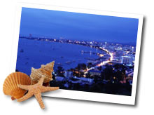
Pattaya A Travelers Paradise


Pattaya is nestled along a picturesque bay on the East Coast of the Gulf of Thailand, roughly 170 kilometers southeast of Bangkok. From a fishing village in the 1960's, Pattaya has emerged as the favorite Southeast Asian vacation center. A fascinating escape where tourists, holiday makers and vacationers from around the world unfold an incomparable array of possibilities to unwind during an exotic holiday beach vacation.